
Niantic Spatial's Large Geospatial Model: A Technical Deep Dive
Executive summary
- Niantic Spatial has trained a visual positioning system on 30 billion images crowdsourced from Pokémon Go and Ingress players, creating a large geospatial model (LGM) that achieves centimeter-level localization accuracy.
- The model enables robust visual positioning in GPS-denied urban environments ("urban canyons") by matching real-time camera imagery against a learned world representation derived from millions of precisely tagged game hotspots.
- First commercial deployment is with Coco Robotics, whose sidewalk delivery robots now fuse this visual model with their four hip-height cameras to improve arrival-time reliability for pizza and grocery deliveries.
- The architecture demonstrates a practical bridge between massive-scale AR gaming data and real-world robotics navigation, turning eight years of consumer AR gameplay into a training corpus for embodied AI.
Niantic Spatial, spun out from the Pokémon Go developer in May 2025, is commercializing a visual positioning system that repurposes a decade of player-generated spatial data. The core technical bet is that the sheer volume and diversity of images—captured by hundreds of millions of smartphones across global urban environments—can produce a more robust localization model than purpose-built mapping fleets or purely geometric SLAM approaches.
Technical architecture
The system is best understood as a large geospatial model (LGM) that performs visual localization. At its core is a deep neural network trained to regress 6-DoF camera pose (3D position + 3D orientation) directly from one or more input images.
Data foundation
- Scale: 30 billion images collected primarily through Pokémon Go (2016) and Ingress (2013).
- Label quality: At over 1 million "hotspot" locations (Pokémon Gyms, PokéStops, Ingress portals), the game strongly encouraged players to visit and point their phones. This produced thousands of images per location from varying angles, times of day, weather, and lighting conditions.
- Rich metadata: Each image includes highly accurate ground-truth pose derived from a fusion of phone sensors (IMU, visual-inertial odometry, occasional good GPS, and Niantic’s own map alignment). Metadata captures not only position but heading, tilt, velocity, and device orientation.
Model training While exact architecture details remain partially undisclosed, the approach is characteristic of modern visual localization pipelines:
- A backbone (likely a ResNet, EfficientNet, or vision transformer variant) extracts dense visual features from input images.
- These features are matched against a learned geospatial embedding space or implicit scene representation built from the 30B image corpus.
- The model is trained with a combination of pose regression loss (typically smooth-L1 or geodesic loss on rotation) and possibly contrastive or reconstruction objectives to learn viewpoint-invariant representations.
- Generalization beyond hotspots is achieved through self-supervised or semi-supervised techniques that leverage the dense coverage around high-traffic game locations to bootstrap understanding of nearby urban geometry.
The resulting model can localize a camera to within a few centimeters using only a handful of snapshots. This is significantly tighter than typical consumer GPS drift (often 10–50 meters in urban canyons) and competitive with high-end RTK-GPS under ideal conditions.
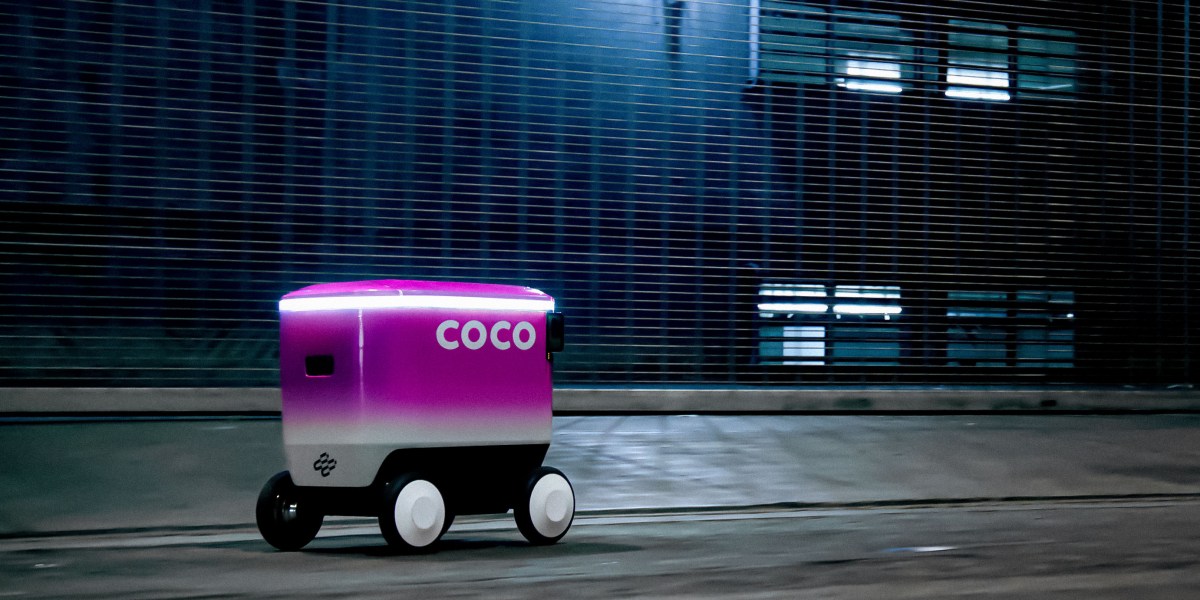
Robot integration (Coco Robotics) Coco’s delivery robots are roughly the size of a large cooler, travel at ~5 mph (2.2 m/s) on sidewalks, and carry up to eight extra-large pizzas. Each robot is equipped with four cameras mounted at hip height, providing near-360° coverage. Although the camera height and field-of-view differ from the typical Pokémon Go player pose (chest/eye height, portrait orientation), Niantic reports the domain gap was manageable through data augmentation and domain adaptation techniques during training.
The robots continue to use GPS when available but fall back to the Niantic visual model when satellite signals are unreliable. The system presumably runs a lightweight version of the localization network on-board or on an edge gateway, periodically querying a cloud-based model for global consistency.
Performance analysis
Concrete public benchmarks remain limited, as the technology was only recently productized. However, Niantic claims:
- Centimeter-level accuracy (typically < 10 cm translational error, a few degrees rotational) at the 1M+ trained hotspots.
- Robustness across day/night, weather, and seasonal changes due to the diversity of the training set.
- Generalization to non-hotspot locations in the same cities, though with expected degradation in accuracy.
Comparison with alternative approaches
| Approach | Typical Accuracy | Coverage Method | Cost Profile | GPS Dependency | Primary Limitation |
|---|---|---|---|---|---|
| Standard GPS | 5–50 m (urban) | Satellite | Low | Full | Urban canyon multipath errors |
| RTK-GPS | 1–5 cm | Satellite + base station | High (infrastructure) | Full | Still fails in deep urban canyons |
| Starship-style geometric SLAM | 10–30 cm | On-board 3D mapping | Medium (per robot) | Low | Requires continuous mapping effort |
| Niantic LGM Visual Loc. | < 10 cm | Crowdsourced 30B images | Amortized over users | Low | Dependent on visual distinctiveness |
| Traditional Visual Loc. (e.g. PoseNet, HF-Net) | 0.5–2 m | Smaller datasets | Medium | Low | Poor scaling to city-scale |
The key differentiator is data scale and label quality. Traditional visual localization datasets (Cambridge Landmarks, 7Scenes, Aachen Day-Night) contain thousands to low millions of images. Niantic’s 30 billion images, with game-driven dense sampling at millions of points of interest, represent an unprecedented spatial prior for urban environments.
Technical implications
This announcement highlights several important trends:
-
Repurposing of consumer AR data for robotics: The same visual data needed to make virtual creatures appear stably in the real world is directly transferable to robot navigation. This blurs the boundary between AR/VR and embodied AI.
-
Emergence of geospatial foundation models: Similar to how LLMs are trained on internet text, Niantic is building a "world model" grounded in real visual geography. Future versions could incorporate semantic understanding, dynamic object prediction, or even commonsense physics learned from observed human and robot behavior.
-
Privacy and consent considerations: While the data was collected through games with location permissions, the secondary use for training commercial robotics models has sparked discussion in the community (as seen in Reddit and news coverage). This raises broader questions about "data dividends" for users who contributed to these models.
-
Acceleration of last-mile robotics: Reliable centimeter-accurate positioning in dense urban environments is a major blocker for autonomous delivery at scale. By reducing missed deliveries and improving ETA predictability, such technology directly impacts unit economics.
Limitations and trade-offs
- Visual dependence: The system can fail in environments with drastic visual change (construction, seasonal foliage, major events) or in visually repetitive areas (identical suburban housing tracts).
- Compute requirements: Running a large visual localization model on a low-cost delivery robot remains challenging; Niantic likely employs model distillation or hybrid edge-cloud inference.
- Geographic bias: Performance will be strongest in cities that had high Pokémon Go adoption between 2016–2024. Rural areas and many cities in the Global South will have sparser coverage.
- Scalability of hotspots: While the model generalizes, the highest accuracy is still achieved near the original 1M+ game locations. True "anywhere" performance may require continued data collection or synthetic augmentation.
Expert perspective
Niantic Spatial’s approach is a pragmatic and technically elegant use of existing data moats. Rather than attempting to build yet another mapping fleet, they leveraged the largest crowdsourced visual dataset ever created for AR. The centimeter-level claims, if sustained across diverse conditions, would represent a significant advance over both commercial GPS and many academic visual localization systems.
The real significance may lie less in the current model and more in the foundation it creates. A geospatial model trained on 30 billion real-world images is a powerful prior that can be fine-tuned for numerous downstream tasks—semantic mapping, predictive navigation, or even training embodied foundation models that understand how cities actually function. The partnership with Coco Robotics is an important first validation, but the longer-term impact will depend on how effectively Niantic can productize this technology for broader robotics and AR audiences.
Technical FAQ
### How does this compare to Starship Technologies' mapping approach? Starship relies on classical SLAM and 3D reconstruction to build local maps of building edges and street furniture. Niantic’s method uses a learned global model trained on vastly more data. The learned approach potentially offers better generalization and robustness to lighting changes, at the cost of requiring a large pre-trained network and possible cloud connectivity.
### What is the expected localization latency and compute footprint on the robot? Not yet publicly disclosed. For real-time sidewalk navigation at 5 mph, sub-200ms end-to-end latency is likely required. Niantic has probably produced a distilled student model or uses a hierarchical approach (coarse localization followed by fine pose refinement).
### Is the model fully end-to-end differentiable or does it use a hybrid feature-matching + PnP pipeline? The article and available materials suggest an end-to-end regression model rather than explicit feature matching + RANSAC/PnP, which is consistent with modern learning-based visual localization research (e.g. successors to PoseNet, DSAC, or HF-Net). Exact architecture details have not been released.
### How does Niantic handle domain shift between phone cameras and robot cameras? The four hip-height, outward-facing robot cameras differ in both height and aspect ratio from typical player phones. Niantic reports using standard domain adaptation techniques, likely including view synthesis, camera intrinsic normalization, and possibly adversarial training to align the two distributions.
Sources
- How Pokémon Go is helping robots deliver pizza on time, MIT Technology Review
- Niantic Spatial Announcement Context
- Niantic Blog on Large Geospatial Model (referenced in multiple reports)
- Community discussion: r/TheSilphRoad
(Word count: 872)